For as long as I can remember, I have known that my paternal grandfather, Leo Bertie Bede NORTHCOTE, was born in Bourke, a town that's located about 800km north-west of Sydney.
Leo Bertie Bede NORTHCOTE 1887-1970
However, I've always found it difficult to find out exactly where he was born in Bourke. The answers would be partially found in my long-held family history files and partially helped along by the information I learned last weekend about how to use land records for family history research purposes from Carol Liston at the Central Coast Regional Seminar.
To start with, I gathered up a few clues about my grandfather's birthplace.
Clue no. 1: Leo's birth certificate
Leo's birth certificate records his birthplace as Tudor St, Bourke.
Source: Extract from Leo NORTHCOTE's NSW birth certificate no. 16549/1887
Clue no. 2: Leo's father's death certificate
Sadly, Leo's father, William Walter NORTHCOTE, died when Leo was only about 11 months old. William Walter NORTHCOTE's death certificate shows that he died in Tudor St, Bourke. So, it seems that the family's home was located in Tudor St, Bourke.
Source: Extract from William Walter NORTHCOTE's NSW death certificate no. 07333/1888
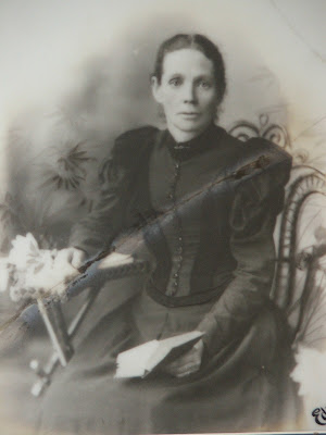
Believed to be William Walter NORTHCOTE 1843-1888
Clue no. 3: Information from my Dad
On Tuesday 8 May 2001, my Dad, Carew Joseph Trevor NORTHCOTE, placed a blogpost online, inviting others to share information about our ancestors who lived for a while in Bourke during the 1880s through to the early 1900s. Dad specifically mentioned the family as living in Tudor St, Bourke.
"The Mother moved back to Orange with some of the children in 1890, leaving some of the older children behind living in the family home in Tudor Stree Bourke."
The information Dad provided about our ancestors in this blog also aligns with the information I remember him telling me verbally about our family's time in Bourke.
Tudor St, Bourke (Photography: Maria Northcote 2012
Tudor St, Bourke (Photography: Maria Northcote 2012
Clue no. 4: Reviewing bankruptcy records
A few years ago, I managed to get copies of my great-grandfather's 1886 bankruptcy records from when he lived in Bourke by visiting the NSW State Archives at Kingswood in western Sydney. I reviewed the pages of these bankruptcy records in search for my great-grandfather's address at the time of the bankruptcy.
Unfortunately, the bankruptcy didn't include his actual address but I did find a clue in these records about where the NORTHCOTE family lived in Bourke in 1886. William Walter NORTHCOTE's bankruptcy records recorded that he owed rent to someone in Bourke named E. A. WEBB who, I have assumed, was probably the owner of the house in which the NORTHCOTE family were living at the time.

Source: Extract from William Walter NORTHCOTE's bankruptcy records, Bourke 1886
Gathering up the clues: Next steps
The four clues above about where the NORTHCOTEs were living in the late 1880s, suggest that the NORTHCOTEs were living in Tudor St in Bourke and they were renting their home from a person called E. A. Webb.
However, to get a more specific answer to exactly where they were living in Tudor Street, I had to dig into the land records and use some of the searching ideas that I learned about last weekend from Carol Liston at the
Central Coast Regional Seminar.
Step 1: Finding details of Bourke on the GNB
Carol Liston suggested starting research into locations by accessing the
Geographical Names Board site. I accessed this site to find out information about the town of Bourke in north-western NSW - including the parish and county names in which Bourke is located.
On this site, I first went to the
Place Name Search and entered "Bourke". The results of this search showed that the town of Bourke is located in the Parish of Bourke in the County of Cowper.
Step 2: Finding old maps of Bourke on the HLRV
Next, I used the information found in my GNB (
Geographical Names Board) search to search the
Historical Land Records Viewer (HLRV) in an attempt to find some old maps of Bourke. As Carol Liston showed last weekend, many old maps include details of land owners, landmarks and even, in some cases, names of tenants.
When I looked up the old maps available for the town of Bourke, I found a map that was dated 1927 but it was based on maps from earlier days, and many of the map markings were dated 1880, 1886 and 1889. So, it seems that although the map was updated in 1927, much of the early information from the 1880s formed the basis of this third edition map of the town of Bourke.
Source: Extract from the third edition of the TOWN OF BOURKE map, 1927, File Name: wl_tnBourke.jp2 from HLRV
Although some of the land-owners' names were difficult to see, I went searching for the name "E. A. WEBB", the person who my great-grandfather owed rent, as noted in his 1886 bankruptcy records. I was in luck. I found at least five town blocks that were labelled with E. A. WEBB's name - one in Tarcoom St, two in Darling St (in the next street, parallel to Tudor St) and two in Tudor St. Since many of my other records mentioned Tudor St as being the location of the NORTHCOTE family home, I have made a guess that the home they lived in was located at one of these properties: either Lot 15 or Lot 16 Tudor St, Bourke, as indicated on the map below.
Source: Extract from the third edition of the TOWN OF BOURKE map, 1927, File Name: wl_tnBourke.jp2 from HLRV
Step 3: Finding the land deeds on the HLRV
Using the information on the 1927 third edition of the map of the Town of Bourke, I found out the Volume and Folio ("vol and fol") reference numbers for lot no. 15 and no. 16 Tudor St Bourke:
Section 37, Lot 15, Volume 562, Folio 193
Section 37, Lot 16, Volume 562, Folio 194
Source: Extract from the third edition of the TOWN OF BOURKE map, 1927, File Name: wl_tnBourke.jp2 from HLRV
I was then able to search, using the vol-fol numbers to find the sale deeds for these two lots. I found that a man called Edward Augustus WEBB, a senior constable, purchased these two blocks for £21 (lot no. 15) and £22 (lot no. 16) on 20 April 1881. Here are some excerpts from the land deeds.
Lot no. 15, Volume 562, Folio 193:
Lot no. 16, Volume 562, Folio 194:
Step 4: Google maps and street view
Next, of course, I wondered what this street looks like today, so I went into Google Maps. Although the numbering system is now different, I estimated that the current block numbers 32 and 34 line up with the old lots 15 and 16.
Source: Extract from the third edition of the TOWN OF BOURKE map, 1927, File Name: wl_tnBourke.jp2 from HLRV
Source: Google Maps, accessed 7 March 2023
I also lined up the above maps with the Allhomes.com.au website's aerial photograph of this section of Tudor St:
Step 5: SIX maps
To double-check my estimation of where the old lots 15 and 16 Tudor St were located in relation to the current numbering system on Tudor St, I accessed the NSW
SIX (Spatial Information Exchange) maps site to find out the DP numbers as well as the old lot numbers and the new numbers for the houses on Tudor St, Bourke.
Above and below: 32 Tudor St (Lot 16), Bourke
Above and below: 34 Tudor St (Lot 15), Bourke
In conclusion ...
So, I now think that my grandfather was born and my great-grandfather died at either 32 or 34 Tudor St, Bourke.


%20Catherine%201903%20Electoral%20Roll%20Rozelle%20ZOOM.jpg)


%20Margaret%201903%20Electoral%20roll%20-%20Drummoyne%20ZOOM.jpg)

%20Margaret%201903%20Electoral%20Roll%20%E2%80%93%20Orange%20ZOOM.jpg)


